Bhubaneswar: After moving northwestwards till May 1 noon, cyclone ‘Fani’ will re-curve north-northeastwards and cross Odisha coast between Gopalpur and Chandbali, to the south of Puri, on the afternoon of May 3 with maximum sustained wind of speed 175-185 kmph gusting to 205 kmph, the India Meteorological Department (IMD), in a late night bulletin, said.
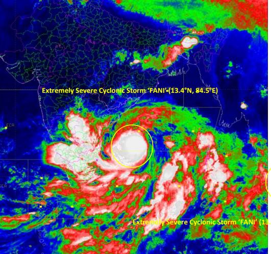
As on April 30: The extremely severe cyclonic storm over southwest and adjoining westcentral & southeast Bay of Bengal, moved west-northwestwards with a speed of about 16 kmph in last six hours and lay centred at 2030 hrs over westcentral and
adjoining southwest Bay of Bengal near latitude 13.4°N and longitude 84.5°E, about 720 km southsouthwest of Puri (Odisha) and 490 km south-southeast of Visakhapatnam (Andhra Pradesh).
Rainfall Warning
May 2: Light to moderate rainfall at many places with heavy to very heavy rainfall at isolated places very likely over south coastal Odisha.
May 3: The intensity is likely to increase with heavy to very heavy rainfall at a few places and extremely heavy rainfall (>20 cm) at isolated places over coastal Odisha and its adjoining districts of interior Odisha on May 3
May 4: Heavy rainfall likely over North Odisha.
Wind Warning
May 2: Squally wind speed reaching 40-50 kmph gusting to 60 kmph is very likely to commence along and off north Andhra Pradesh and Odisha Coasts.
May 3: Gale wind speed reaching 60-70 kmph gusting to 85 kmph likely from the morning and become 175-185 kmph gusting 205 kmph over Odisha coast and 90-100 kmph gusting to 115 kmph over adjoining districts of north Andhra Pradesh (Srikakulam, Visakhapatnam
and Vijayanagaram districts) by the evening.
Storm Surge Warning
Storm surge of about 1.5 meter height above astronomical tide is very likely to inundate low lying areas of Ganjam, Khurda, Puri and Jagatsinghpur districts of Odisha at the time of
landfall.
Expected Damage
In Ganjam, Gajapati, Khurda, Puri and Jagatsinghpur districts
(i) Extensive damage to all types of kutcha houses, some damage to old badly managed
Pucca structures. Potential threat from flying objects.
(ii) Extensive uprooting of communication and power poles.
(iii) Disruption of rail/road link at several places.
(iv) Extensive damage to standing crops, plantations, orchards.
(v) Blowing down of Palm and coconut trees.
(vi) Uprooting of large bushy trees.
(vii) Large boats and ships may get torn from their moorings.
In Kendrapara, Bhadrak, Jajpur, Balasore districts
(i) Total destruction of thatched houses/ extensive damage to kutcha houses. Some
damage to pucca houses. Potential threat from flying objects.
(ii) Bending/ uprooting of power and communication poles.
(iii) Major damage to Kutcha and and Pucca roads. Flooding of escape routes. Minor disruption of railways, overhead powerlines and signalling systems.
(iv) Widespread damage to standing crops, plantations, orchards, falling of green coconuts and tearing of palm fronds. Blowing down of bushy trees like mango.
(v) Small boats, country crafts may get detached from moorings.
(vi) Visibility severely affected.
Comments are closed.