Heavy Rain & Strong Wind In Puri, Ganjam As Cyclone Fani Moves Closer To Landfall
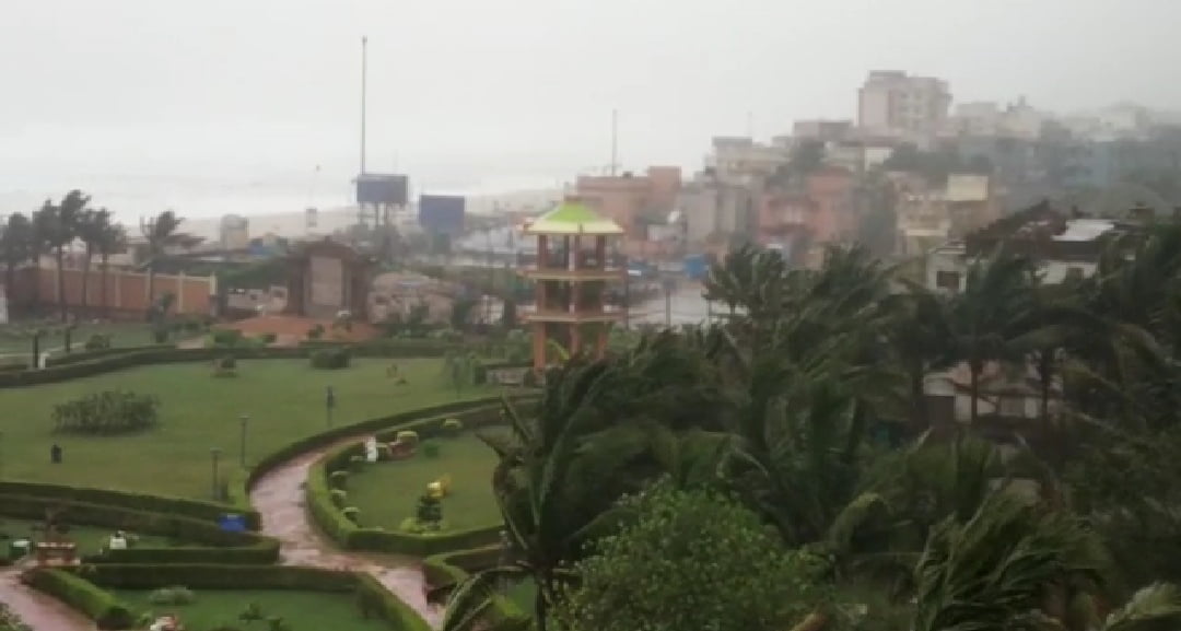
Puri/ Bhubaneswar: Rain has started lashing hard and the wind speed increased abnormally in Satapada and areas south of Puri as Cyclone Fani assumed menacing proportions on Friday early morning.
The cyclone is expected to make its landfall between Puri and Gopalpur soon. Weather office sources said the exact location of landfall cannot be ascertained but it would possibly take place in the vicinity of Satapada in Puri district and Rambha in Ganjam district. Chilika, a brackish water lake, flows in this region. It could happen between 8 am and 10 am.
Locals in Satapada told Odisha Bytes that it was no longer safe to step outdoors because of the gusting wind. The Indian Meteorological Department (IMD) has predicted that the wind speed would touch 170 kmph to 180 kmph with gusting of 200 kmph.
“Its raining heavily and the wind is blowing dangerously creating a bristling sound. It will sweep us off our feet if we go outdoors,” said Alok Behera, who stays in Satapada.
In Ganjam too, a heavy downpour accompanied with very strong winds is being experienced, triggering panic in the low-lying areas.
The state government said close to a million people have been evacuated since Thursday from the vulnerable areas. While an estimated 3 lakh people were shifted to safer places in Ganjam, around 1.3 lakh people were moved out of their homes in Puri district. The State Emergency Operation Centre, Bhubaneshwar, has used Location Based Alerting System and sent 1.2 crore SMS to people in different zones of vulnerability urging them to take precautions and move to cyclone shelters in view of Extremely Severe Cyclonic Storm ‘Fani’, official sources informed.
According to the Met office, by 2.30 am on Friday Gopalpur recorded 10 cm rainfall, followed by Kalingapatnam (9cm) and Puri (9 cm). At 4.30 am, Gopalpur registered 105 kmph wind speed and 14 cm rainfall.
The weather office said the ‘extremely severe cyclonic storm FANI’ over west central and adjoining north-west Bay of Bengal moved north-northeastwards with a speed of about 16 kmph in last six hours ending 0230 hrs IST and lay centred over north-west and adjoining west central Bay of Bengal near latitude 18.9°N and longitude 85.4°E, about 110 km south-southwest of Puri, about 65 km south-east of Gopalpur, about 260 km east-north-east of Vishakhapatnam (Andhra Pradesh), and 450 km south-southwest of Digha (West Bengal).
It is very likely to move north-northeastwards and cross Odisha Coast between Gopalpur and Chandbali, south of Puri during 3rd May forenoon with maximum sustained wind speed of 170-180 kmph gusting to 200 kmph. Landfall process is very likely to continue till noon/afternoon of 3rd May.
After the landfall the system is very likely to continue to move north-northeastwards, weaken gradually and emerge into Gangetic West Bengal as a Severe Cyclonic Storm with wind speed of 90-100 Kmph gusting to 115 Kmph by early morning of 4th May. It is very likely to move further north-northeastwards and emerge into Bangladesh on 4th May evening as a Cyclonic Storm with wind speed 60-70 Kmph gusting to 80 Kmph.
Comments are closed.